
BY Lee McClellan
(This article is the thirty-first in the periodic Blue Water Trails series highlighting the floating, fishing and tourism opportunities on Kentucky’s streams and rivers).
FRANKFORT, Ky. – Bath County was once a center of iron production in Kentucky and produced a great percentage of the iron smelted west of the Blue Ridge Mountains in the early years of Kentucky statehood.
Jacob Meyers left Pennsylvania in 1782 to search for iron ore deposits in the wilderness of Kentucky. He eventually held nearly 10,000 acres along Slate and Mill Creeks and began construction of an iron furnace in 1791.
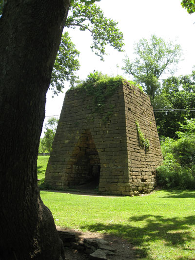
The Bourbon Furnace, also called the Old Slate Furnace, used local ores to produce kettles, plowshares, nails and cookware of such quality that the U.S. Navy contracted the furnace to produce cannonballs. Many made their way down river to New Orleans during the War of 1812. Andrew Jackson fired cannonballs produced by this furnace during his victory over the British at the Battle of New Orleans.
Bourbon Furnace still stands sentinel along the banks of Slate Creek and the public park around it serves as an excellent access point for floats on the stream. Slate Creek flows through the heart of scenic Bath County, where the Outer Bluegrass Region meets the Cumberland Plateau. Several floats on Slate Creek showcase this incredibly scenic and overlooked corner of Kentucky.
The best water flows for Slate Creek are between 75 and 200 cubic feet per second (cfs). Consult the Slate Creek Gauge on the U.S. Geological Survey’s stream flow webpage at http://waterdata.usgs.gov. David Baker, stream biologist for the Kentucky Department of Fish and Wildlife Resources, sees smallmouth bass up to 17 ½ inches and largemouth bass over 18 inches in Slate Creek during population monitoring. The biologists rate the rock bass population as excellent.
Baker said the flowing outside bends make the best smallmouth bass habitat on Slate Creek while woody cover in deeper water holds largemouth and spotted bass.
The first float begins in Montgomery County at the historic community of Howard’s Mill, once on the road to the most fashionable resort of early Kentucky, Olympian Springs. The springs served as the terminus of Kentucky’s first stagecoach line, coming from Lexington. Legend states that Henry Clay won, then lost, the resort in a poker game.
Paddlers may park and launch boats at the Mt. Sterling water treatment plant at Howard’s Mill on KY 1331. The take-out is nearly 5 ½ miles downstream at the Little Egypt Ford on Ford Road (also called Snedegar Road on some maps) off KY 1331, for a relatively short shuttle. Be sure to launch boats well below the low-head dam. A steep path leading from the gravel parking lot grants access.
The first part of this float flows straight until bending right several times in a rough horseshoe shape. Pitch 3-inch green pumpkin-colored tube jigs rigged on 1/8-ounce leadheads for smallmouth bass on the outside flowing bends in this stretch.
Slate Creek then makes two bends to the left, the second of which features a small bluff. The rocky shoals in this bend hold smallmouth bass. Just downstream on the right, a small, but deep, pocket holds Kentucky (spotted) bass. The creek then makes two opposite sharp bends, the first to the right with the second to the left. These bends should be probed for smallmouth bass.
After the second bend, the creek flows relatively straight until bending to the right. The take-out at Little Egypt Ford is on the right, just downstream of the bend.
The next float begins at Little Egypt Ford and ends 13 miles downstream at the bridge over Slate Creek on Kendall Springs Road off KY 36 in Owingsville. This is an extremely long float for a stream of this size and paddlers should plan to launch near daybreak to reach the take-out at dusk.
The beginning of the float flows straight before a nearly 180-degree bend back to the left, nearly flowing back into itself. The rocky outside banks of this bend hold smallmouth bass.
This stretch contains some remarkably deep holes and those with abundant woody cover hold largemouth and spotted bass. A black 4-inch finesse worm rigged on a 1/16-ounce leadhead draws strikes. Let the light worm slowly fall from branch to branch of the sunken tree top. A largemouth bass hiding in such lairs attacks this presentation.
Baker recommends that anglers paddle through the many long, shallow holes with little current in this stretch. Concentrate on the flowing water in the bends and where rock bars constrict and increase the flow.
Slate Creek makes a perfectly shaped horseshoe bend to the left about the time paddlers hear the rumbling of commerce on Interstate 64. Baker said this section of creek holds abundant rock bass, especially in the mouth of Salt Well Creek, which enters Slate Creek on the left just before the I-64 Bridge.
The take-out is on the left, just downstream of a low-head dam at the Lions Club Park. The low-head dam must be portaged on the left. A small access road parallels Kendall Springs Road on the right just before the bridge over Slate Creek.
The next float begins at this access and ends nearly 4 miles downstream at the Old Slate Furnace (Bourbon Furnace) Park on KY 36, just south of Owingsville. This makes an excellent half-day float with a quick shuttle.
The creek bends gently to the left at the beginning of this float before making a sharp turn to the right. Anglers should work a green pumpkin tube jig in the flowing water on the outside of this bend for smallmouth bass.
Slate Creek makes two more sharp bends to the right that hold smallmouth bass. After a relatively straight stretch, the waters of Mill Creek enter Slate Creek on the right.
The mouth of Mill Creek holds rock bass that strike black and silver in-line spinners. Slate Creek often runs slightly stained. In-line spinners attract largemouth, smallmouth and spotted bass as well as rock bass in stained water.
The take-out at the park is on the right, just downstream of the mouth of Mill Creek. Ample parking with an easy carry awaits paddlers at the park.
The next float begins at the Old Slate Furnace Park and ends at the low water ford on Water-Dell Road off KY 111. This float requires a long shuttle, but is the best section of Slate Creek for smallmouth bass.
Biologists see the largest smallmouth bass in this stretch of the stream. Slate Creek runs fairly straight before flowing under the I-64 Bridge at the beginning of this float. After the bridge, the creek makes a series of bends that hold smallmouth bass.
After flowing around the I-64 Motorplex and under the U.S. 60 Bridge, the creek flows in an “S” shape. A double-tailed skirted grub in the motor oil color worked in the flowing water on the outside of these bends is a good choice for smallmouths.
Slate Creek then flows relatively straight for a long ways and receives the waters of Prickly Ash Creek on the left and Skillet Branch on the right.
After paralleling KY 111 for a time, the current of Slate Creek slows from the influence of Forge Mill Dam downstream. The dam lies downstream of a hard bend to the right. Floodwaters carved a small channel around the right abutment of the dam, making an easy portage at normal water levels. The take-out is on the left, a short distance from the dam.
The last float is for the intrepid. The put-in is on Water-Dell Road. The take-out is 5 ½ miles downstream on the Licking River at the site of the historic Wyoming Ferry. This ferry, just downstream of the mouth of Slate Creek, served as an important crossing of the Licking River and thrived with a charge of .50 cents for vehicle or horse, each way. Modern highways made Wyoming Ferry obsolete. It closed in 1950.
The rock strewn bends at the beginning of the float hold smallmouth bass as does the flowing water above and below the many gravel bars in this stretch. Largemouth and spotted bass hold in any woody cover. Anglers may encounter a muskellunge from the Licking River in spring and fall on this float.
The take-out on Ferry Road is unmarked and runs to the left a short distance from the second entrance to the Old Wyoming Road loop off KY 111. Look for a power pole on Ferry Road as well as the old cable that guided Wyoming Ferry, still lodged and hanging from an enormous sycamore tree along the river there. This access is crude and muddy with parking for only two vehicles.
Owingsville has abundant accommodations for paddlers. Visitors can combine a weekend of paddling on Slate Creek and fishing Cave Run Lake, which forms the southeastern border of Bath County.
The Blue Water Trails series supports Gov. Steve Beshear’s Adventure Tourism Initiative. Log on to Kentucky Fish and Wildlife’s Blue Water Trails webpage at fw.ky.gov for a detailed map.
Bath County Tourism:
www.bathcountytourism.com
Author Lee McClellan is an award-winning associate editor for Kentucky Afield magazine, the official publication of the Kentucky Department of Fish and Wildlife Resources. He is a life-long hunter and angler, with a passion for smallmouth bass fishing.

Be the first to comment