
By Lee McClellan
Editor’s note:(This article is the twenty-third in the periodic Blue Water Trails series highlighting the floating, fishing and tourism opportunities on Kentucky’s streams and rivers).
FRANKFORT, Ky. – Trammel Fork and Middle Fork of Drakes Creek rise in the northern Highland Rim area along the Tennessee border in Allen County. The two forks flow into Warren County where they meet the main stem of Drakes Creek that drains into Barren River near Bowling Green.
The gravel substrate of Trammel Fork, Middle Fork and Drakes Creek allows floodwaters to carve holes of varying depths, reminiscent of the world famous blue ribbon smallmouth streams of the Arkansas and Missouri Ozarks. The Drakes Creek system is vastly different water than smallmouth streams flowing through the limestone sections of Kentucky where the water is rarely over an adult’s head. Trammel Fork, Middle Fork and Drakes Creek also hold largemouth bass, spotted bass, rock bass, bluegill and a few muskellunge.
Fisheries personnel with the Kentucky Department of Fish and Wildlife Resources routinely see smallmouth bass from 15 to 18 inches long in this system. Trammel Fork, Middle Fork and Drakes Creek also have many riffles that make the paddling interesting, but are easy enough for beginners and families.
Western Kentucky University has a helpful website for paddlers on the Drakes Creek system called the Warren County Blueways at www.wku.edu/blueways. The website features an interactive and printable map with GPS coordinates, locations of put-in and take-out locations, floating mileages and other important information along with links to participating partners. This map corresponds with brown metal markers at the put-in and take-out locations on the river to avoid confusion and also on the map that accompanies this article.
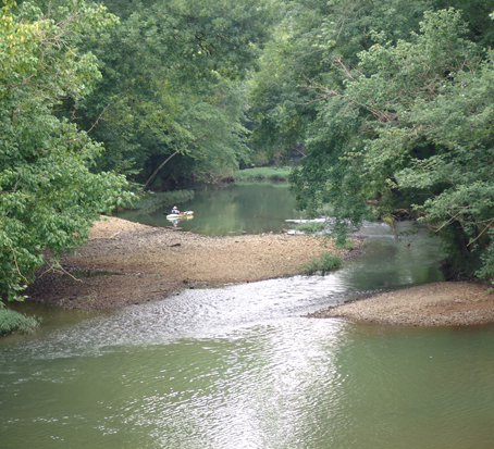
In its journey from its spring-laden headwaters to its confluence with Drakes Creek, Trammel Fork has deep holes, gravelly shoals and riffles that make ideal habitat for smallmouth bass.
The first float on Trammel Fork of Drakes Creek begins near the Warren and Allen County line at the KY 240 Bridge on Woodburn – Allen Springs Road and ends two miles downstream at Boyce – Fairview Road Bridge in Warren County. Limited parking exists at the put-in at the KY 240 Bridge.
Trammel Fork in this section has many long, moderately deep holes interspersed with gravel bars and braided stream drops. This float makes an excellent half-day float for anglers pursuing black bass, rock bass or sunfish.
The second float begins at the Boyce – Fairview Road Bridge and ends five and one-half miles downstream at Romanza Johnson Park on Mt. Lebanon Road in Warren County. This float makes an excellent full-day float for those who plan to fish and half-day float on a straight paddle.
Boaters may put in at the KY 240 Bridge and paddle to Romanza Johnson Park on Mt. Lebanon Road for a seven and one-half mile float. Those who plan to fish should put in early in the morning and plan to take out at dusk on this stretch.
Fly rod anglers interested in smallmouth bass should try the Middle Fork of Drakes Creek. The Middle Fork is much smaller and intimate compared to Trammel Fork and offers excellent opportunity for fly casters to present black deer hair poppers and larger chartreuse cork poppers to woody cover in the flowing shoals and above and below riffles. The top-water bite grows stronger as the days shorten and water cools in September.
Due to its small stature, deadfalls blocking the stream can be a problem on the Middle Fork and may require some portaging, especially after high flow periods.
The put-in for this float is on Goodrum Road in Warren County for a nearly four-mile paddle to the KY 240 Bridge on Woodburn – Allen Springs Road near the community of Drake. Parking for several vehicles and an easy carry down at the Goodrum Road access awaits boaters. However, the KY 240 Bridge access has limited parking and presents a long carry over private property that requires landowner permission. Paddlers can shorten this float to about three miles by putting in at the ford on Duncan Road, also known as White’s Chapel Road.
The next float is on the main stem of Drakes Creek. It begins at the KY 240 Bridge near Drake and concludes roughly five miles later at Romanza Johnson Park. Boaters need to paddle a short distance up Trammel Fork to the park which enters Drakes Creek on the right.
This section of Drakes Creek has many sharp turns that create flowing outside bends that hold smallmouth bass. Target these areas with a 4-inch black double-tailed skirted grub on a 3/16-ounce standup leadhead. Larger smallmouth bass prefer this presentation.
This stretch also features many sandbars slightly under water. Swim a 3-inch green pumpkin-colored curly-tailed grub just over bottom in these areas for smallmouths. Grubs really shine on hot days during low flow periods.
The next float begins at Romanza Johnson Park and ends about six miles downstream at Phil Moore Park in U.S. 231 near Bowling Green. This stretch is perfect for paddlers who want to spend a day on the water without worrying about time or difficulty of paddling. Both of these parks close at dusk.
Drakes Creek widens and deepens in this stretch and the same outside bends hold smallmouth bass, but anglers should also work the woody cover in the slower holes for spotted and largemouth bass. A pearl-colored weightless soft plastic jerkbait draws strikes when slowly worked alongside the submerged wood. A four-inch black finesse worm rigged on a 1/16-ounce leadhead and allowed to slowly fall beside this cover is also a deadly tactic for these fish.
Two take-outs await paddlers at Phil Moore Park. One is on the left just upstream of the U.S. 231 Bridge. Warren County Parks and Recreation installed a concrete pad for paddlers to land boats and gain their footing in current before ascending the steps to the parking area. The other take-out is about one mile downstream around a bend to the left. Look for a small set of concrete steps.
The last float on Drakes Creek begins at Phil Moore Park and ends about five miles downstream at the KY 2629 Bridge on Old Scottsville Road. The KY 2629 Bridge access has extremely limited parking and a long carry. Do not block the farm gates while parking vehicles here.
This section flows much more river-like and holds good numbers of largemouth and spotted bass. Anglers should also target sunken brush and tree tops for surprisingly large bluegill.
This section also holds some large muskellunge that migrate upstream from Barren River. Fish flooded timber with a large black and gold minnow-shaped crankbait for muskellunge.
Paddlers should consult the Drakes Creek near Alvaton, Kentucky gauge on the Kentucky Streamflow page at the U.S. Geological Survey’s website at www.waterdata.gov. For Trammel Fork and Drakes Creek, flows of at least 100 cubic feet per second (cfs) are best for minimal dragging with a 150 cfs minimum for the Middle Fork. Anglers can float these at lower flows, but expect to drag.
The upper stretch of Trammel Fork at the Concord Church Road Bridge and Blankenship Road Bridge in Allen County offers excellent wade fishing for trout at these two Kentucky Fish and Wildlife Voluntary Public Access Sites. Springs feeding Trammel Fork drop the water temperature low enough for trout to survive year-round.
Scottsville and Allen County offer plenty of antiquing for visitors to accompany paddling the Drakes Creek system. Both Allen and Warren counties’ strategic location on the main transportation routes from Louisville to the interior of the South provided much Civil War action in the area.
Scottsville/Allen County Chamber of Commerce: www.scottsvilleky.info. Bowling Green Area Convention and Visitors Bureau:www.visitbgky.com
The Blue Water Trails series supports Gov. Steve Beshear’s Adventure Tourism Initiative. Log on to Kentucky Fish and Wildlife’s Blue Water Trails webpage at fw.ky.gov for a detailed map.
Author Lee McClellan recently won awards for the Blue Water Trails series and is associate editor for Kentucky Afield magazine, the official publication of the Kentucky Department of Fish and Wildlife Resources. He is a life-long hunter and angler, with a passion for smallmouth bass fishing.
-30-
The Kentucky Department of Fish and Wildlife Resources manages, regulates, enforces and promotes responsible use of all fish and wildlife species, their habitats, public wildlife areas and waterways for the benefit of those resources and for public enjoyment. Kentucky Fish and Wildlife is an agency of the Tourism, Arts and Heritage Cabinet. For more information on the department, visit our website at fw.ky.gov.

Be the first to comment